
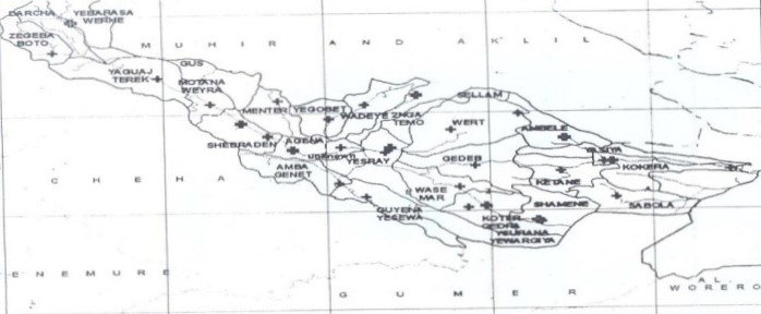
Ezha district is one of 16 districts and 8 city administrations in Gurage zone. The capital of the district is 42 km from Wolkite, 198 km from Addis Ababa, 402 km from Hawasa, the capital of the region, and 58 km from Butajra city. The boundaries of the district are Mhur Aklil in the north, Cheha in the south, Gumer in the east and partly Silte zone and Abeshge district in the west. The district is organized into 24 Kebele administrations and 3 municipalities (Shamen, Bojebar and Zgbaboto). According to Hbekoko (1999) 2.9% rate, the population in 2015 is 130874 (Men 64126 (48.99%) Women 66748 (51.01%)), which covers 7.37% of the population of the zone. In addition, up to 280 people live in one square kilometer, and it is estimated that the average number of people in a family will be seven.
Ezha District lies geographically between 8003′ to 8016′ North Latitude and 37050 to 38012′ East Longitude; The arid climate of the district is divided into three, with dry plains 10%, highlands 53% and plains 37% of the climate. Most of the areas of the district receive rain during the regular rainy season from June to September, and the average annual rainfall is 1000–2400 ml. And data show that the average temperature is 100–200c; When looking at the way of life of the people, the information indicates that they are mostly settled in the highlands and live in the dry plains (wet plains) and plains.
The economic base of the people is agriculture, and among the marketable products are barley, teff, beans, potatoes, cabbage, corn, garden vegetables (cabbage, tomatoes, carrots, carrots, garlic) and fruits (mango, avocado, apple, plum, banana). cow’s milk and khata (Khata edulis) are also marketed from animals such as bulls, cows, sheep, goats, horses and donkeys.
According to the data of the regional file office (1999), the surface area of the district is 34500 m2 (345.1 ha), of which agricultural land is 14529 ha (42.1%) (of which 6392.76 ha (44%), permanent crop 8136 ha (60%), irrigated) Covered 76.2 ha (0.22%), Grazed 5826 ha (16.89%), Forested 6909.5 ha (20.02%), Shrub 1370 ha (5.97%), Institutionalized 284.98 ha (0.826%), Vegetated 702.3 ha (2.03 %), occupied by houses and villages 1832.5 hectares (5.5%), cultivable 1910 hectares (5.53%) and uncultivable 185 hectares (0.536%), swampy land 25 hectares (0.07%), 135 hectares (0.04%) It is estimated that 100 hectares (0.029%) are owned by others;
Since 1993, strong efforts have been made to ensure a fair distribution of social service institutions in the district. There are 38 schools in the district (8 from 1-4, 27 from 1-8 and 3 from 9-12) and a Construction and Industrial College in Agna. 10+4) available; In the health sector, there are 4 health centers, 24 health checkpoints at the Kebele level and 1 hospital in Agena city (built with 37 million Birr, started operation in 2014) and 9 private clinics are providing services. In the movement to improve the financial system by making the society develop the culture of saving, various savings associations that help the economic activity of the society are organized and operating from district to kebele. Bank (YG 2015), OMO Bank (2015), Awash Bank (2015) and Vision Fund (YG) are small credit institutions providing services to facilitate the social and economic development of the people; In addition, according to the government’s focus on the Glo sector, the 4 private banks have opened branches in Aqna City and are serving their customers.
| Year | Men | Woman | Total |
|---|---|---|---|
|
2011 |
57,142 |
59,478 |
116,620 |
|
2012 |
58,799 |
61,203 |
120,002 |
|
2013 |
60,504 |
62,978 |
123,482 |
|
2014 |
62,259 |
64,804 |
127,063 |
|
2015 |
66748 |
66,748 |
130,874 |


©2023. የእዣ ወረዳ ኢኖቬሽንና ቴክኖሎጂ ጽ/ቤት ከአገና ኮንስትራክሽን እና ኢደስትሪያል ኮሌጅ ጋር በመተባበር. All Rights Reserved.